 Many thanks to SWLing Post reader, Bill Patalon, for sharing this article via Gizmodo:
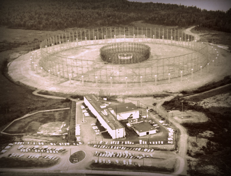
In the early days of electronic espionage, the US intelligence community didn’t have the benefit of all-seeing spy satellites—it had to intercept and interpret high-frequency radio waves transmitted by the Soviet Union. To do so, the Americans relied on a network of mysterious structures whose real purpose was kept highly classified throughout the Cold War.
Nicknamed “Elephant Cages” by outside observers, these structures were actually high-frequency antenna arrays, part of the US military’s AN/FLR-9 “Iron Horse” system. These arrays, commonly known as “Wullenweber” antennas—and named after German WWII scientist, Dr. Hans Rindfleisch was Wullenwever—are a type of Circularly Disposed Antenna Array (CDAA). They can be used for a variety of purposes from intelligence gathering and identifying high-value targets to navigation and search and rescue operations.
Each elephant cage consisted of an inner ring of antennas tuned for high frequency waves surrounded by one or more outer rings tuned for lower frequencies. These antennas would listen for HF radio waves bouncing off the ionosphere (which is what also allows HF radios to communicate beyond the horizon) and triangulate the precise location of the signal’s source.
Click here to continue reading at Gizmodo…
If you’d like to read more about “Elephant Cages” check out the following links:
So I wonder why they just built a new one in Florida?
Sometime back around 2005-2009, I was doing maintenance on a NOAA climate station near Bondville, IL, and noticed several tall utility poles in the distance. As I figured they looked suspiciously like an antenna array, I asked the site caretaker (it was University of Illinois Champaign-Urbana farm) what they were. He happily took me to see what was left of the original Wullenweber test site, built under contract for the US government for testing by Dr. Hayden. All that remained then was several utility poles, and some transmission line sticking out of the ground.
I’ve also seen the Navy’s array at Imperial Beach, CA (near San Diego), down the highway from the SEAL base, and it’s very impressive. It’s clearly visible from the highway, and though I’ve read it was supposed to come down years ago, its still standing. Makes me wonder if it’s still in use.
Another interesting site I’ve seen is outside of Barrow, Alaska. Near remnants of the DEW Line is a joint USAF/FAA radar station, with a single white domed antenna. I don’t remember exactly, but pretty close to it is what looks to me like a “mini” Elephant Cage. From what I recall, it was a single ring of fairly short towers, surrounding a small central building. When I asked about the facility, I was only told it belonged to an “unnamed agency.”
The first 2 are clearly visible from the following link, while the Barrow site doesn’t stand out enough to be obvious in the Google images. Click on the “markers” button in the lower left to jump to all the sites.
http://tinyurl.com/k5jhxuv
Here’s the full, ugly URL:
http://mapper.acme.com/?ll=40.04958,-88.38087&z=16&t=H&marker0=71.32743,-156.63164,6.8 km NE of Barrow AK&marker1=32.59363,-117.12913,1.9 km NW of Imperial Beach CA&marker2=40.04958,-88.38087,7.2 km S of Bondville IL