 Many thanks to SWLing Post contributor, Nick Hall-Patch, who shares the following article originally published in the IRCA’s DX Monitor:
2024 Solar Eclipse DXing
by William Scott, WE7W
DXing the mediumwaves promises to be an exciting event on April 8 during the 2024 total solar eclipse. I’ve been mulling over the DX possibilities a lot lately and have come to some conclusions. I think it boils down to three promising DX scenarios:
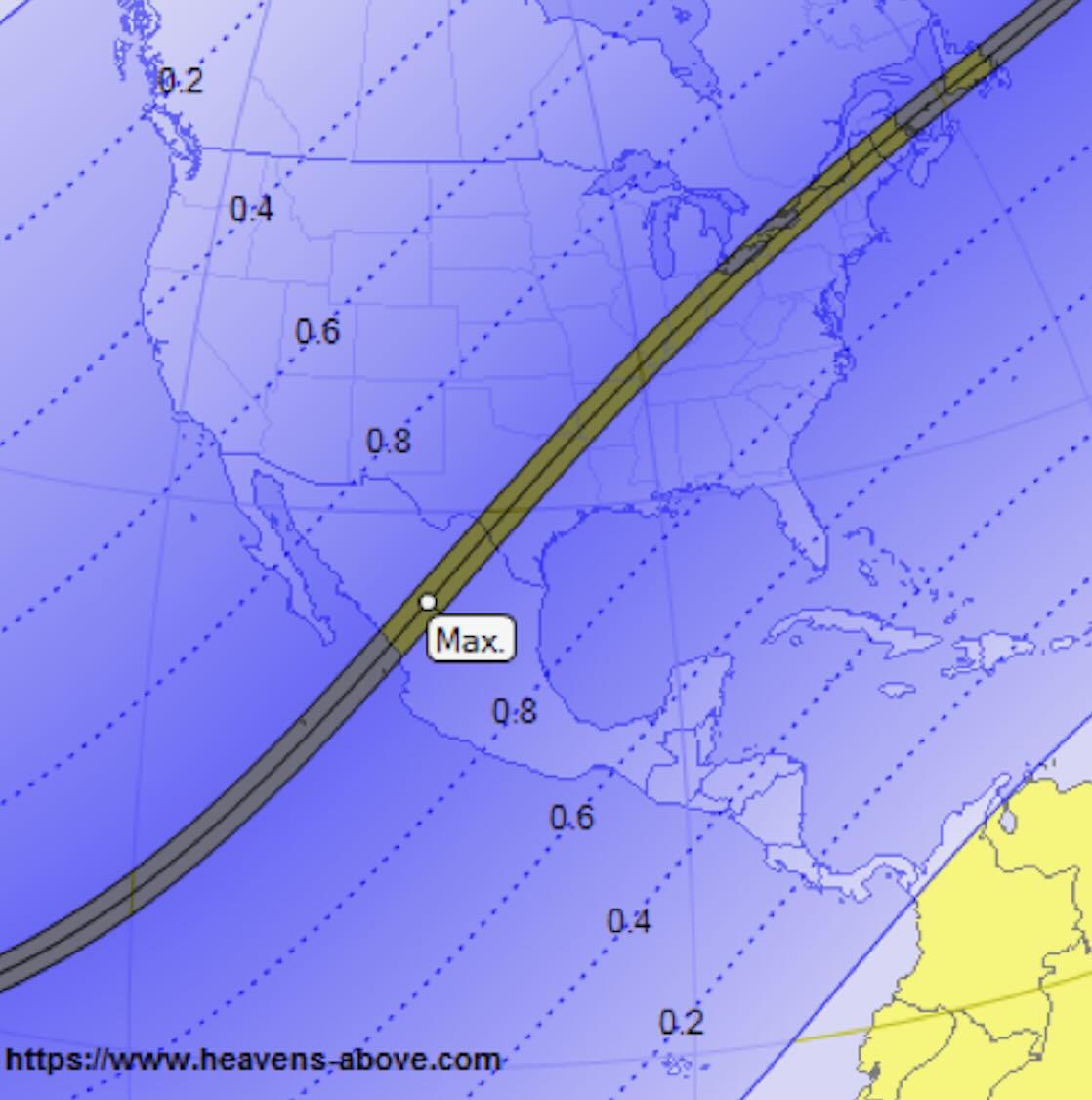
- Scenario 1. For those who live within or very near the path of totality (see Figure 1), I believe best chances of DX would be first to listen to your southwest, along the path where totality is approaching. Darkness will already have happened in that direction, and a certain amount of residual de-ionization of the ionosphere will still remain. After the point of totality passes your location, I would swing my attention to the northeast.
- Scenario 2. For those living within about 800 km (or about 500 miles) of the path of totality I believe best chance would be a perpendicular path across the totality path to a point roughly equidistant on the other side. This puts the signal reflection point right at the center of the totality path, or the deepest point of darkness.
- Scenario 3. For those living more than about 800 km from the path of totality I believe best chance would be along a line from your receiving site to a perpendicular intersection to the totality path. This should define the greatest shaded path.
I think that scenarios #1 and #2 have the best possibility for DX.
Across the U.S. and Canada, from its entry at Texas to its exit through NE Canada and into the Atlantic Ocean, the totality path width varies from a maximum of 199 km at U.S. entry to about 160 km at Atlantic exit, or 123 to 99 miles.
Important to keep in mind – skywave signal strength analysis is based almost entirely on the condition of the ionosphere at the reflection point, not at the receiving site. For single hop propagation, normally the reflection point is at the halfway point to the station along the great circle route. That 800 km distance from the totality center I wouldn’t hold as gospel. I’m throwing that figure out as a point where scenario #2 may start to transition to scenario #3.
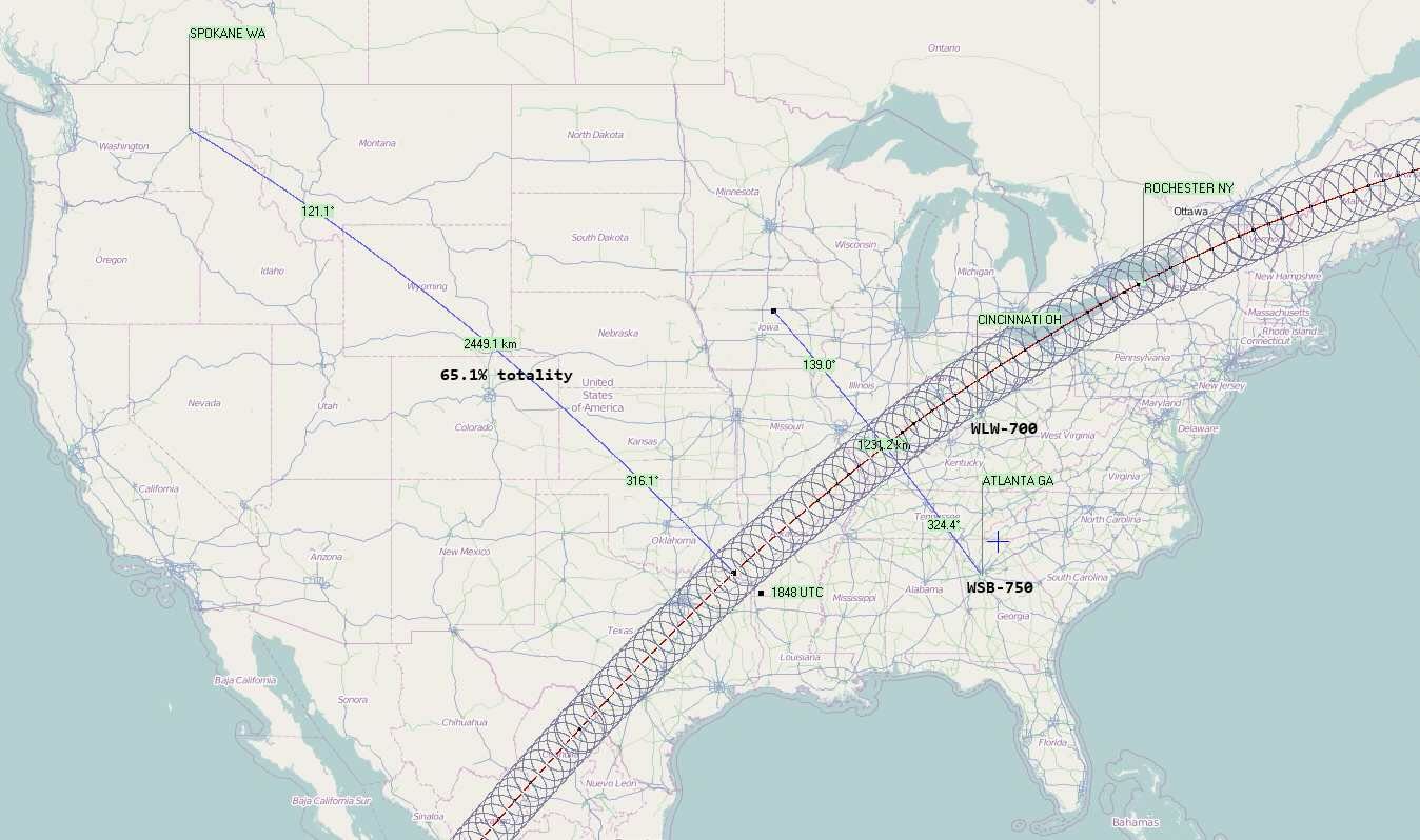
Timing is of the essence for DXing. The shadow velocity exceeds 1000 mph, increasing from 1587 miles per hour at Eagle Pass, Texas to 3176 mph at Houlton, Maine. You may have only minutes to DX. I’ll be in Rochester, NY at the time of totality, and we are right at dead center. I’ll be scenario #1. My plan is to listen to my southwest initially, where totality is approaching. I’ll be listening particularly for WLW-800 in Cincinnati, OH, WHAS-840 in Lexington, KY, and others along or near that path.
Scenario #2 possibly holds the most promise. Calculate your distance to the path center line and look for stations on a direct line across the totality path and at an equal distance on the opposite side of the path from you. One such scenario might be WSB-750, Atlanta to a reception point in northwestern Illinois, central Iowa, or southern Wisconsin or southern Minnesota. Many possibilities on cross-paths exist here. I feel best results would be with a signal path that crosses the path of totality closest to 90 degrees.
A question was raised about the possibility of DX from Spokane, Washington, an extreme distance from the path of totality. That particular scenario would be scenario #3, more than 800 km to the path of totality. Maximum obscurity should be when northeast Texas (let’s say the Dallas area) is experiencing full totality, as the great circle line to the totality path intersects at approximately 90 degrees to the line at that point. This would be at about 1848 UTC. I would listen for any signals along a great circle path between Spokane to anywhere from the Dallas area and northward. Obviously, Spokane to Dallas is an extremely long one hop path, at about 2450 km. At that distance, the reflection point is near Denver, which will have a solar obscuration of 65.1% at maximum.
A Dallas area reception would be next to impossible I would think, but there are many more stations along that great circle path one could try for. Closer stations will obviously move the reflection point closer and start to reduce the solar obscurity. I did a scan along that path and there are some 340 stations within 200 km either side of the line of the great circle path between Spokane and Dallas.
A presumed Scenario #4.
Another scenario was suggested by Nick Hall-Patch, that of reception parallel to the path of totality and outside the 100% totality band. The 2017 solar eclipse across the northern part of the U.S. was DXed extensively and produced some interesting results, which are well documented in IRCA Reprints. Check their document repository here:
http://dxer.ca/images/stories/2019/irca-reprint-index.pdf
Nick reports: “The receptions of KSL-1160 described in IRCA Reprint # G-096 showed the results of 3 DXers listening across the path of the eclipse (Scenario #2), but the fourth, Dave Aichelman, was monitoring KSL from a location parallel to the eclipse path ( sort of Scenario #1?) and got very good enhancement as well.” We might name this “Scenario #4”.
I checked out # G-096, that documents the KSL reception from the solar eclipse of 2017. It looks like the Dave Aichelman (at Grants Pass, OR) reception of KSL had a mid-path reflection point of about 95% solar obscurity. The distance was 971 km (602 miles). Graphing KSL, I see it has a nice fat low angle takeoff and impressive skywave strength at 900 km, some 1.3 mV/m for that distance. (ed. note: A map of fractional solar obscuration is in Figure 2, easily converted to the percentage figures quoted in this article. )
Better yet, the article indicated Aichelman also received XEPE-1700 across the Mexican border from San Diego too. That was a mid-point reflection obscurity of only about 83% as far as I can deduct from the maps. The distance was 1238 km (769 miles). The mid-path reflection point there was in the neighborhood of 700 km from the central path of totality.
So, DX is indeed possible where both the station and the receiver are off center from the totality path. It’s looking like anything from at least 80% obscurity at mid-path reflection may have some real possibilities, particularly if you are at the end nearest the path of totality. Lower obscurities, perhaps down to 50% or so may even produce results.
Check out these links.
https://nationaleclipse.com/cities_partial.html
https://eclipse.gsfc.nasa.gov/SEpath/SEpath2001/SE2024Apr08Tpath.html
https://eclipse2024.org/eclipse_cities/statemap.html
Using my pattern mapping program which has extensive area search capability, I’ve compiled a list of all US and Canadian stations that fall within the 2024 Solar Eclipse path of ~100% totality. There are 456 stations. Results are drawn from the March 20 FCC LMS database and Industry Canada database. Sorry I don’t have Mexico available.
If you would like this list, download from this link. https://www.mediafire.com/file/125ih5yrmw4puib/2024-eclipse-stations-by-longitude.zip/file
Across the US and Canada, from its entry at Texas to its exit through NE Canada and into the Atlantic Ocean, the totality path width varies from a maximum of 199 km at US entry to about 160 km at the Atlantic exit off Newfoundland, or 123 to 99 miles. 456 stations are found in this eclipse path. I purposely set the path width to 210 km from start to finish. This gives a few km slop on both sides of the 100% totality path for good measure.
Unzip the downloaded .ZIP file, where you will find 3 files. The stations in each file are sorted by longitude, from west to east. This gives us the progression of the eclipse path, with the eclipse starting at the first station in the list and ending with the last station.
File #1 is a simple text file.
File #2 is in .CSV format. You can easily input it to an Excel file.
File #3 is in .HTML format. It includes links to each station’s Google Map latitude-longitude coordinates for the satellite view of the transmitter tower array.
Another link takes you to the FCC AM Query link for that station. I hope these files are beneficial. There should be many propagation path possibilities outside of this list as well.
(reprinted from the author’s blog at https://radio-timetraveller.blogspot.com/ )
********
Further sources of information concerning the eclipse include the following websites:
(Clicking anywhere on this map page will give all the information you need about obscuration, length of eclipse etc.at a given location). Also:
https://www.greatamericaneclipse.com/april-8-2024
https://eclipsewise.com/2024/2024.html
 Animations of the path of the eclipse versus time can be seen at:
https://eclipsewise.com/solar/SEanim400/2024_04_08_TSE_400px.gif
http://7dxr.com/4all/100km8Apr-movie–Frissell-HamSCI.mp4
The latter is particularly interesting, as it shows the moon’s shadow at 100km height above the earth, an area of special interest to DXers, as it is the lower edge of the E-region of the ionosphere. Note especially that as the eclipse ends over the North Atlantic Ocean, that there is a temporary darkness path between Europe and North America, because night will already have fallen in Europe. So will there be blips of TA DX in eastern North America as the eclipse passes by? Listen, and find out!
Finally, our DX could be of interest to ionospheric physicists also. The rapidly changing listening conditions will be indicating a similarly turbulent ionosphere, and DXers’ documenting those listening conditions through SDR recordings could provide information that will be useful to scientists who want to gain a better understanding of the Earth’s ionospheric dynamics.
HamSCI is an organization of volunteer citizen-scientists and professional researchers who study upper atmospheric and space physics, and will be interested in examining MW DXers’ wideband SDR recordings made during the eclipse period, and indeed, in having DXers assist with HamSCI’s research. (see https://hamsci.org/eclipse. Especially if you are an amateur radio operator, there are several other ways that you might also contribute to the project.)
(This first appeared in IRCA’s DX Monitor and is used with permission. See https://www.ircaonline.org/default.php for club details)

