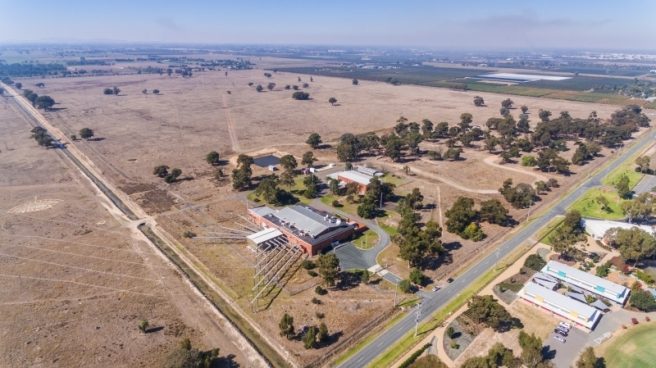
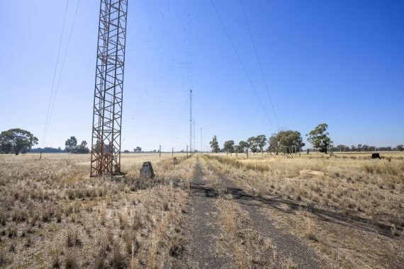
Many thanks to SWLing Post contributor, Nigel Holmes, who writes:
Those of you who hold amateur (VK) licenses – form an orderly queue to book a spot.
Those of you who listen – make space on your shack wall for the last QSL card from Shepparton IHFTS.
A special callsign has been issued by ACMA for the event: VI3RA (Victor India…)
Amongst other experimental transmissions, will be an attempt will to reflect radio signals from the Moon using the high gain HF aerials at Shepparton. Frequencies in the 18 & 21 MHz amateur bands would be employed. This would emulate the ground-breaking work done by CSIR Radiophysics Laboratory in the 1940s from the Shepparton station which initiated Australia’s entry into radio astronomy.
Click here for more information about VI3RA at QRZ.com and SADARC.org.
Note that the event with take place March 14-15, 2020 (GMT +11:00).
Thank you for the tip, Nigel! I’ll certainly attempt to put Shepparton in the logs! If I lived in anywhere near Shepparton, I’d make the pilgrimage to be in that long line of people hoping to light up one of those massive antennas!
I hope if any SWLing Post readers attend the event or operate as VI3RA, they’ll perhaps snap a few photos to share here with the community!


Signed up for an SSB slot, will get some video. Cheers…
Thank you, Gordon!
“As any halfway-competent RF engineer or even ham (it’s the basis of one of the questions in the Advanced, and I think Standard, licence theory tests here) familiar with HF propagation modes could tell you, NVIS won’t work at 26MHz. About 15MHz is the highest that’ll reflect back down at NVIS angles, and the practical upper frequency limit is more like 5 or 6 MHz.”
Any half decent engineer will test these modes in reality as the DRM has done https://www.drm.org/wp-content/uploads/2019/02/DRM-Handbook.pdf Annex 4 it was tested in Mexico, India, Brazil and Germany and at different latitudes the Ionosphere reacts differently.
None of which give any indication of NVIS at 26MHz; they’re all either tests/trials of NVIS at MW / low HF frequencies, or line of sight at 26MHz. Granted, sometimes two different tests/trials are reported in the same study/white paper/article, but that shouldn’t confuse an intelligent reader.
Not one of them – and you should be well aware of this, having had it patiently explained to you many, many times – tested NVIS at anything like 26MHz. Sorry, but I’m going to have to side with a whole century’s worth of study into ionospheric propagation by independent, military, and government experts, and not the belligerent misreadings of a self-styled “broadcasting consultant and technical author” who’s repeatedly demonstrated immunity to infection by basic facts.
https://www.baicommunications.com/our-services/broadcast-services/sitefinder/#map
Shepparton – Mooroopna VIC, Australia
It states Triangular Guyed Mast | 92m which doesn’t match what it currently there!
I don’t understand the concentric circles
Still on the data base
Type in Alice Springs and Roe Creek HF near Hugh is still on the data base. The Tennant Creek and Katherine HF sites have gone.
Nigel,
It is interesting that BAI Communications is taking this step. Have they sold the site? They have been trying to sell part of the Commonwealth land in Hamersley WA for housing despite the sign saying that RF radiation is dangerous in the area they want to sell. This was going on about 6 months ago but it has gone quiet. This is their second attempt. They must be hard up for money! The ABC paid them $184 million + SBS’s $72,320 for all digital TV and radio transmissions.
It is also interesting for timing because https://www.acma.gov.au/consultations/2019-08/future-delivery-radio-services-australia-consultation-132019 is yet to report to the minister after more than 7 months.
A high powered high frequency DRM transmitter in the centre of Australia transmitting ABC NewsRadio and ABC Grandstand and is also capable of transmitting Emergency Warning System signals which will wake radios and sleeping listeners, switch to the voice message, display a map and detailed instructions including TPEG data to route vehicles around the Emergency. This warning can be limited to the affected area within 7 km square. This could cover all of Australia. There is only low scrub in that area, it is away from cyclones and floods and invasion. This is far more reliable than fire and wind prone sites which combine mobile phone, wireless NBN, FM transmitters and TV on the one elevated site which can easily have the power line burnt down.
I got a particularly good laugh out of the following in one of the submissions:
“ACMA to investigate in the Australian context the use of Near Vertical Incidence System which aims the signal at the ionosphere and have it shower around the transmitter site at 26 MHz as compared to 2.3 – 5 MHz.”
As any halfway-competent RF engineer or even ham (it’s the basis of one of the questions in the Advanced, and I think Standard, licence theory tests here) familiar with HF propagation modes could tell you, NVIS won’t work at 26MHz. About 15MHz is the highest that’ll reflect back down at NVIS angles, and the practical upper frequency limit is more like 5 or 6 MHz.
G’day Ron – with the currently depressed state of the ionosphere you’d be lucky to get much HAS (high-angle skywave) return at 6 MHz. Of course that means less path attentuation for low-angle moon-sounding at > 17 MHz. The original Shepparton “EME” transmissions in the 1940s were conducted at sparrow’s fart for a particulary cool ionosphere.
Yes, aware of that. Someone else in this thread might need it explained to them (once again, for the nth time) though 😉