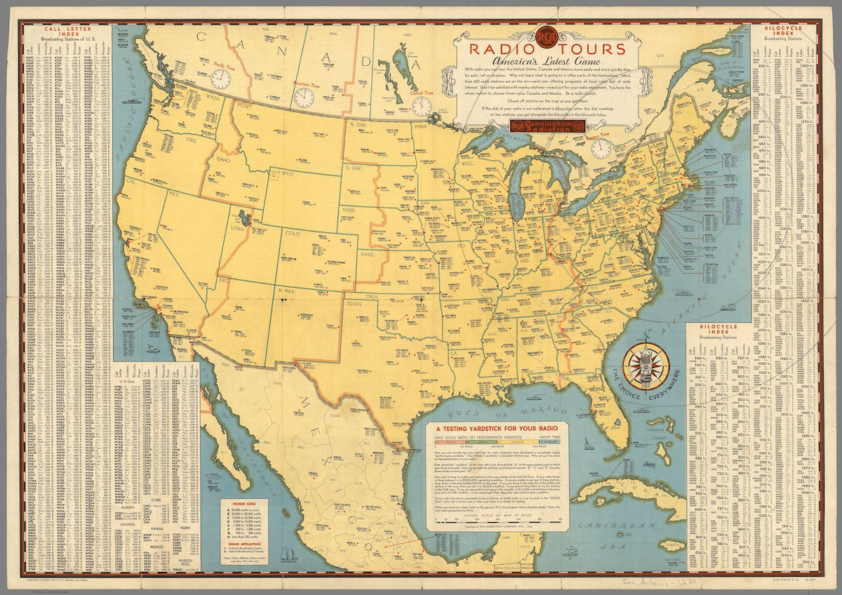
My friend, Maristella Feustle, recently shared this classic RCA “Radio Tours” map of North America. RCA printed this in 1934–during the Great Depression–when most people could not afford to travel. Their map encouraged families to use their radios to travel the world over the air and experience local culture & music.
As Maristella pointed out, the detail on this map is pretty darn amazing.
Click here to download a high resolution image of this RCA map.
Thank you for posting this! Really cool map, which not only shows what stations were available in 1934 – but also what their pre-NARBA shift frequencies were too. I downloaded it, but it would have been oh so cool to have received the real thing!
The name rang a bell and I have the 1933 version in plastic hanging on my wall next to me. Saw it in an antique store many years ago. Separating at the main east/west fold but I show off the nice red cover and 10c price with the RCA logos.
Thanks for the Map. I was surprised to find out that KDKA was not on the current 1020 Freq in 1934. Also, it was neat to confirm that WLW stayed steady on 700. I used to have a 1934 Model 242 radio that had some of the stations actually printed on the dial.
Good ideas on printing.
Quite a few towns are misplaced, such as Durham, North Carolina, and Charlottesville, Virginia.
It’s strange that RCA didn’t include any SW QRG’s, most sets had that dial.
Please, someone reproduce it… Enough of us out here that’d want it for the wall.
You can download a hi res JPG and send it to any online picture printing source and get one. Don’t know what size it could be without it image falling apart but if it could do 16×20, it would be pretty good! Whaddaya want for free?
I grew up travelling the world and now haven’t for the past decade. Shortwave I find shortwave a great way to recreate that feeling of cultural exploration and keeping the same worldly views alive. Weather shortwave listening or talking to ham operator in the middle of nowhere. It’s great.
This is great! I’d love to have a large copy to put in my radio room. Interesting to see stations that are still on the air and how the time zones have moved. Thanks for sharing!
It’s a hi-res JPG. You could send it to an online printer and they would mail you a copy back.
A big chunk of northwest Florida is in Central time zone. The line is nominally the Apalachicola River except that the Eastern zone takes a big detour west along the coast. This was done early on so that a little local railroad could be entirely in one zone. Here we are a century-plus later with the railroad gone and a lot of chrono-geo-graphical confusion. Eh, what’s done is done.
That thing is so cool, especially the “testing yardstick” feature!
As a bit of a map “geek” I find this interesting. But more so was the time zone lines/borders.
I’d always imagined that state boundaries and a time zone boundary would coincide. It looks like that in 1934 they didn’t..!
And today, what deferences are there ?
Michigan is the big difference that I see. Today all of the lower peninsula and all of the Upper peninsula excluding the counties that border Wisconsin are in the eastern time zone. Without looking I’m not sure where the rest of the eastern time zone line currently runs.
Knoxville, TN was in the Central time zone back then, whereas today it is in the eastern zone.
I have an old 1940’s road map of VA that showed the westernmost portion in Central Time. When I was a kid and saw that, i didn’t think that could be right. Well, it’s exactly the same here. Not sure how well the Atlanta area did split between time zones but the boundaries do make more sense than the current ones as far as sunrise/sunset times go.