Monthly Archives: February 2022

Jock shares: “A bit more about NOAA Weather Radio”

Photo by Raychel Sanner via Unsplash

Many thanks to SWLing Post contributor, Jock Elliott, who shares the following guest post:


A bit more about NOAA Weather Radio

By Jock Elliott, KB2GOM

Okay, I’ll admit it: I’m a fan, an advocate, an evangelist for NOAA Weather Radio (NWR).

Why? Because, quite simply, if you live in the United States, it is one of the very best deals you are ever likely to get. NWR is the voice of the National Weather Service. It is the fastest and most reliable means of receiving alerts when hazardous weather approaches.

NWR includes more than 1000 transmitters, covering some or all of 50 states, adjacent coastal waters, Puerto Rico, the U.S. Virgin Islands, and the U.S. Pacific Territories. Broadcasts are found in the VHF public service band at these seven frequencies (MHz): 162.400, 162.425, 162.450, 162.475, 162.500, 162.525, and 162.550. Radios capable of receiving NWR signals may include consumer radios, ham radios, scanners, and dedicated weather radios.

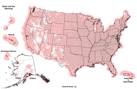
For more information about coverage, check these:

NOAA Weather Radio is free. There are no commercials, you don’t have to wait for other programming to be completed to hear the weather forecast, and, because it is radio, you can listen and get a concise summary of what’s going on with the weather in your area while you are doing something else. Even better, the folks at the National Weather Service tell me that over 80 percent of the NWR transmitters have some form of backup or emergency power, many of which can continue to operate for 5-10 days while the main power is out. There is a wealth of information about NWR here: https://www.weather.gov/phi/nwrfaq scroll down to see details.

Why do you want a receiver that can hear NOAA Weather Radio? Short answer: because every state in the Union has some form of hazardous weather that could prove lethal. Early warning just might save your life.

In his excellent book Warnings – the true story of how science tamed the weather, Mike Smith points out how successful meteorology has been at saving lives. In the 1950s, with the beginning of the tornado warning system, the death rate from tornados was 1.5 deaths per million people. By 2009, the death rate was down to .068 deaths per million, a decrease or more than 95 percent. The investment weather radar, prediction techniques, and warning systems such as NWR has paid handsome dividends.

So what makes an NWR-capable radio good? First, sensitivity. Greater sensitivity increases the odds that the radio will be able to hear more NWR stations in your local area, which in turn raises the probability that you’ll be able to hear an NWR station with backup power when the lights go out.

Second, alert capability. An alert function – that is, the ability to put the radio in standby mode and have it automatically switch on when NWR transmits an alert tone is a great plus. You can go about your business, and the radio will wake up and alert you when you need to pay attention.

Third, advanced alert capability. Ideally, you would like to be alerted only when a hazard is close to your immediate vicinity. Some dedicated weather radios and advanced scanners offer Specific Area Message Encoding (SAME) that can be programmed by the user to only alarm for weather and other emergency events in specific, desired counties, thereby eliminating unwanted alerts for areas that are not of concern to the listener. In addition, some weather radios have a selectable alert option that can be programmed to alert only when certain hazard codes – ranging from Avalanche to Winter Storm Warning – have been selected by the user and are transmitted by the local NWR station.

With that in mind, here are some NWR-capable radios with which I have had personal experience. With each radio, I did a quick search from the same location to see how many local NWR stations it would receive, as a rough indication of sensitivity. The good news is that every single one of the radios below could receive at least two NWR stations in my local area and had basic alert capabilities.

Consumer radios with AM/FM receive

CC Skywave SSB

CCrane 2E –could hear clearly 3 NWR stations in my area, basic alert function, house mains and battery power (over 200 hours).

CCrane Skywave SSB – could hear 2 NWR stations clearly and one scratchy, basic alert function, battery power (over 50 hours).

Eton FRX3+ — could hear NWR 3 stations clearly, basic alert capability, power options include solar, hand-crank dynamo, and rechargeable battery (can also be recharged off house power with USB capable), internal battery can be used to recharge cell phone battery.

Ham radio hand-talkies

Icom V80 with aftermarket high-performance antenna – could hear 2 NWR stations clearly and one scratchy, basic alert capability.

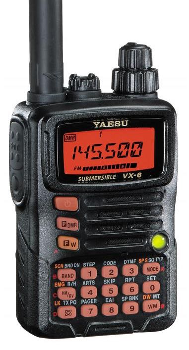
Yaesu VX-6 with Diamond 77 aftermarket antenna — could hear 2 NWR stations clearly and one scratchy, basic alert capability.

Scanners

Uniden BC125AT with Diamond 77 aftermarket antenna – could hear 3 NWR stations clearly, basic alert function.

Uniden SDS200 with homebrew off-center-fed dipole antenna (see below) – could hear 6 NWR stations clearly, highly sophisticated programmable SAME and specific hazard alert functions, no battery power (the SDS100, handheld version of this scanner provides battery power); would require uninterruptible power supply or something similar if mains power goes off. Author’s note: while the performance is stellar, this is by far the most expensive option. With the stock antenna that comes with the SDS200, I could hear two NWR stations clearly.

Dedicated NOAA Weather Radio Receiver

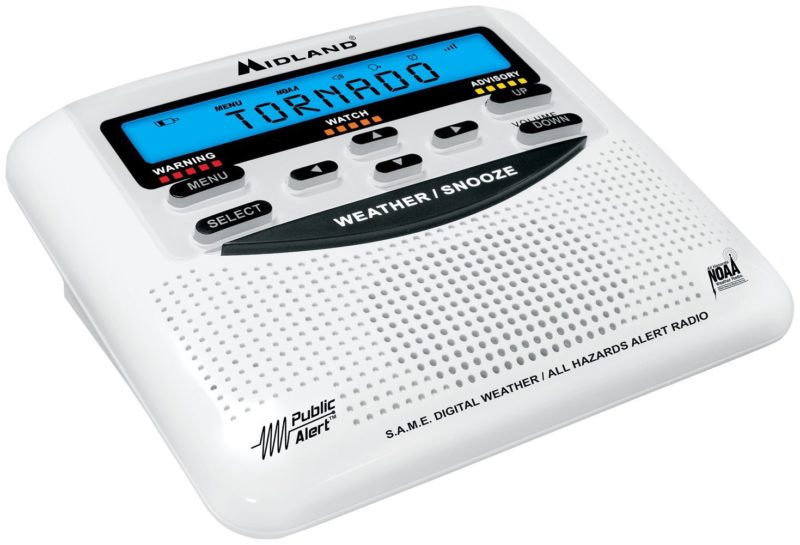
Midland WR120 Weather Alert Radio – At the time I began this write-up, I did not own a dedicated weather radio receiver, so I reached out to www.midlandusa.com, and they were kind enough to send me this unit, which is built solely to receive National Weather Radio stations. With the built-in whip antenna extended, the receiver was clearly very sensitive. I could hear 4 of my local NWR stations clearly, and 2 more scratchy but copyable. If you are in a fringe area, there is a socket for plugging in an external antenna such as the one I describe below.

There is a little symbol on the box that says “EZ Progamming,” and I was pleasantly surprised that it was true. Between the MENU and SELECT keys, it is easy to walk through the setup. I thought that I would have to look up the SAME code for my location, but the WR120 has a built-in database of all the states and counties, so selecting my county was a snap. In addition to SAME programming, the WR120 has a long list of selectable alert options that you can choose to meet your needs. That list can be downloaded here: https://cdn.shopify.com/s/files/1/0531/2856/0817/files/SAME_List_of_Emergencies_Non-Weather_Emergencies.pdf?v=1636648846

The WR120 is powered by a tiny wall-wart transformer that plugs into house power, and the user installs 3 AA batteries to provide back-up power in case the lights go out. The manual does not say how long it will operate on battery power.

It seems to me that if you do not already own a device that will receive NOAA Weather Radio stations, the WR120 would be an excellent choice.

Boosting Performance

If you want to boost the performance of the radio you are using to listen to NOAA Weather Radio, I can highly recommend this antenna: https://wiki.radioreference.com/index.php/Homebrewed_Off-Center_Fed_Dipole .

I built the wire version, hung it inside in a corner of my radio shack, and with it attached to either Uniden scanner or my Icom V80 ham handi-talkie, I can hear six NWR stations from my location. This antenna offers a large boost in performance for a modest investment of time and money.

In his blog, Smith argues that each of us ought to have redundant means of alerting us to hazardous weather: an app on your smart phone, plus an NWR-capable radio with alert function at home, plus your local TV or radio stations. To which I say: darn good idea!

Spread the radio love

TX Factor Episode 28

Many thanks to SWLing Post contributor, Eric (WD8RIF), who notes that the 28th episode of TX Factor was recently released. Here’s the show summary:

Episode 28

It’s been over a year since our last episode was released so we’re trying to make up for lost time by releasing show number 28 almost eight years after our first show back in February of 2014. Where have the years gone?!

In this show, Bob and Mike get to grips with constructing a digital voice modem using an MMDVM module kit and Raspberry Pi Zero, and Bob reviews the long-awaited ID-52 5W hand-held transceiver from Icom. As always there’s a chance to win a bundle of books from the RSGB in our free-to-enter draw. See here for terms and conditions and full details of how to enter. Don’t forget we also provide a podcast of the GB2RS news every week. Details of how to download or subscribe are here.

Click here to view on YouTube.

Spread the radio love

The 2021 Milcom Files now available on Amazon

Many thanks to Teak Publishing who shares the following press release:


The 2021 Milcom Files – TSM Edition – Now Available on Amazon

Recent world events continue to draw many radio listeners into their radio shacks to tune in on the action using their shortwave radios. software-defined radios, and programmable VHF/UHF scanners. In many cases monitoring the HF/VHF/UHF radio spectrum offers the radio hobbyist an opportunity to hear what is really going on behind the scenes without the filters imposed by news media outlets. Most radio listeners quickly learn that when the world has a crisis, disaster or tensions rise between countries, the military will usually be the first organization called upon to intervene. It pays to monitor military frequencies when international events heat up.

There is a big radio frequency spectrum out there to monitor if you know where to listen, you can eavesdrop on some of the most fascinating radio communications you will hear on a scanner or shortwave radio.

In this regard, the Teak Publishing Company is pleased to announce the release of their latest eBook in the TSM Milcom Archive series – The Spectrum Monitor Volume 4 (2021) by Amazon best-selling author Larry Van Horn.

Some of the topics covered in this new book during 2021 include:

  • The World of Strange Military Stations
  • Military Callsigns
  • US Coast Guard 911 Network and Monitoring Coast Guard Cutters
  • Monitoring UHF Military Satellites and DoD Defense Satellite Network
  • Military Land Mobile Radio Systems Primer
  • Monitoring Military Auxiliary Radio System (MARS) including frequencies and

callsigns

  • NTIA GMF Release and HF – VHF – UHF frequencies
  • Bonus Material: The Spectrum Monitor 2021 Air Show Guide
  • Bonus Material – The Teak Action Bands (LW-MW-HF) Military Frequency List –

Hundreds of discrete U.S. and some foreign military frequencies.

The latest Milcom Files – TSM Milcom edition 226-page eBook is available now on Amazon for just US$4.99. [Note SWLing Post affiliate link.]

Larry Van Horn N5FPW, has been a radio hobbyist for more than 58 years listening to world events and monitoring military radio communications. He has spent over 40 years documenting activity in the military radio spectrum in his monthly Satellite, Utility World, and Milcom (Military Communications) columns in the pages of Monitoring Times, Satellite Times, and now The Spectrum Monitor magazines.

During this time, he has published a treasure trove of military communication monitoring information. All his early MT columns have been published into two e-Books by Teak Publishing. The first two books in the Milcom Files series cover his columns published in Monitoring Times and have previously been published at Amazon. Book one of The Milcom Files covers the columns published from 1998 to 2006 and Book Two covers the period 2007 to 2013

In 2017 Larry joined the Spectrum Monitor writing staff where he continues to chronicle military monitoring in his monthly TSM Milcom column. Now he is publishing all his monthly TSM Milcom columns (2017-2021) at Amazon in the Kindle eBook format. All the books in The Milcom Series archives are available at https://www.amazon.com/gp/product/B078MNXGND.

If you are interested in monitoring military comms. own a scanner, shortwave radio, or have an Internet connection for web software-defined radio (SDR) monitoring, then the Milcom Files are a must reference for the radio library shelf.

For additional information on this and other Teak Publishing radio hobby books is available on the company website at https://www.teakpublishing.com/. Information on other publications by the Larry is available on his author’s page at Amazon http://www.amazon.com/-/e/B00G1QMO4C.

Spread the radio love

Seeking a repair shop in Spain to fix a faulty Eton E1 display

Many thanks to SWLing Post contributor, Jesus Leal, who writes:

Greetings Thomas,

I would like to ask you a question…
Could someone from the SWLing Post Community… tell me where I can fix 1 Eton E1 Radio… that I bought in Spain in 2009… and 2 years ago the Display screen turned off… and nothing can be seen…
Everything works but there is no possibility to see anything on the Display..
In Spain… several radio repair services… including Grundig Official Service… have not been able or have been able to fix the Display…
That is my query..
If any member of the SWL… could help me…
Thank you .. and greetings from Spain …

Let’s see if someone in the SWLing Post community can help you out.  If you were State side, I’d recommend my friend Vlado, but the international shipping alone would make that a very costly repair. Something within Spain or the EU would be more reasonable. 

Please comment if you know of a radio repair service in Span or possibly the EU that might be capable of fixing this E1.

Spread the radio love

Video: WWII Bunker Hidden Inside Gibraltar’s Rock

An aerial view of Gibraltar. Photo by Adam Cli.

Many thanks to SWLing Post contributor, John (KC8RZM), who writes:

Hi Thomas,

[The following] is a fascinating little documentary I found on YouTube.

A secret bunker hidden inside Gibralter’s rock with a self-contained transmitter and self-generating power source (a bicycle frame).

The radio details start at the 11 minute mark:


Just thought some SWL might find it interesting, I sure did.

Best,
John
KC8RZM

A fascinating documentary!  Thank you for sharing, John!

Spread the radio love

Guest Post: Calculate Station Distances Using Excel Formulas

Many thanks to SWLing Post contributor, Bob Colegrove, who shares the following guest post:


Calculate Station Distances Using Excel

By Bob Colegrove

Introduction

On occasion, I’ve wanted to know just how far away a station was from my home.  I’ve never been much of a contester, but I know distance can play a part in the results.  There are a number of Internet cites which let you enter latitude and longitude information and then calculate the distance across the surface of the earth.  These are alright on an occasional basis, but I often wind up getting the data mixed for the two locations, and it is not handy when you want to make several measurements.  Here’s a way to generate the distance from your home to thousands of stations with just a little effort.

Many years ago, armed with my faded knowledge of high school trigonometry, I used Excel to calculate the surface distance between any two points on earth.  I managed to find the spreadsheet (file dated 1998) which has no fewer than 11 steps in the algorithm.  Although it worked, when I came back to it a few months later to make a change, I couldn’t remember my thought process.  There are Internet sites which develop earth surface calculations in highly esoteric terms and heavy-duty math.  But life is short, and I wanted to cut to the chase.  There are, in fact, several formula variations which have somehow managed to distill all this down to a neat single-cell calculation, and they seem to work very well.

Construction

The spreadsheet figure below is the simplest form used when you have decimal latitude and longitude data as input.  The convention is to use negative numbers for the Western and Southern Hemispheres.  Home is your reception location and all other locations are compared with that to determine the distances.  If you’re curious, the home location (yellow cells) used in these examples is the monument marking the geographic center of all 50 US states in Belle Fourche, South Dakota.  Google Maps is one easy source to determine the exact latitude and longitude of any point on earth.

To calculate the distance between any two points on earth, copy the formula below directly into a cell, then change the reference cell names as appropriate, and you’re ready to go.

=ACOS(COS(RADIANS(90-$B$5)) * COS(RADIANS(90-B9)) + SIN(RADIANS(90-$B$5)) * SIN(RADIANS(90-B9)) * COS(RADIANS($C$5-C9))) * 3959

$B$5 and $C$5 are the cell references for your home address (yellow in the figure above).  Of course, the dollar signs indicate these data remain fixed in each calculation.  B9 and C9 are corresponding latitude and longitude for the example radio station, WTOP (green).  Change these four cell locations as necessary.  The constant, 3959, at the end of the formula is the average radius of the earth in miles.  Use 6371 if you want kilometers.  The data cells in Columns D and E are populated with the formula and produce the result. These values are dynamic and can be replicated down the columns for the rest of your station location data.

Degrees, Minutes, and Seconds Format

The US FCC on-line database contains latitude and longitude tower locations for medium wave stations in Region 2, North, South, and Central America.  However, coordinates are in degrees, minutes, and seconds format and must be converted to digital format for calculation of distances.  The conversion process can also be done in Excel.

In this case, the inclusion of the coordinate hemispheres, N or S, and E or W is important.  Whereas, the hemispheres in the decimal example were signed + or -, the inclusion of the appropriate letters here is necessary.  Cell L5 reads

=IF(H5=”S”,-I5-(J5/60)-(K5/3600),I5+(J5/60)+(K5/3600))

and cell Q5 is similar for longitude, except “W” is substituted for “S.”  These formulas are then replicated in columns L and Q for each data item.  Columns R and S contain the distance calculation formulas as described above.  Line 14 is not necessary, but can be used to see if your formulas are correct; that is, the distance from home to home should be zero.

Let Excel Get the Information for You

What follows is for anyone tired of copying cumbersome latitude and longitude data.  Unfortunately, it only works on the current version of Microsoft 365 Excel, and apparently goes off into the big cloud in the sky to instantly download the information.

  1. Enter the town followed by either the US state, Canadian province, or other country name (Column A).
  2. Copy these locations to the next column (Column B).  The cells in Column B will become temporary geography cells.  Note:  As shown above, the data have already been converted to geography format (Step 4).
  3. Make sure you have all the geography cell locations selected (Column B).
  4. On the Data ribbon select Geography.  A map icon will appear at the left of each cell, and the state, province and country will be truncated.
  5. For the first latitude (Cell C7), enter =B7.Latitude; likewise, =B7.Longitude in Cell D7.
  6. The formulas in C7 and D7 can be replicated down your list.
  7. Columns for miles and kilometers (E and F) can be added using the distance formula as described above.

The geography data (Column B) cannot be replicated.  If you want to add data later, you will have to reapply the geography format for the new data.  Or, latitude and longitude can still be inserted manually for any additional entries.  The geography data (Column B) are not needed beyond this point and can be deleted or hidden.

Note:  I logged on to my first mainframe computer in September 1976 and have never ceased to be amazed at what these confounded things can be made to do.  I tried as best I could to trip the system with small, obscure towns in faraway places, as well as duplicate names.  I finally succeeded with a relatively large city, Ulaanbaatar, Mongolia.  To be fair, I tried to get it to accept alternate spellings.  So, if you need that one, you’ll have to enter it manually.

Medium Wave Example

This example is for medium wave DXers in Region 2, the Americas.  It makes use of the FCC AM database at https://www.fcc.gov/media/radio/am-query.  The database currently contains more than 24,500 entries, many of these are duplicate entries for stations using different daytime and nighttime powers.

  1. Download the database as a pipe-delimited text file.
  2. Import the file into Excel.
  3. Create additional columns to convert the latitude and longitude data from degree-minute-second format to decimal as described above.
  4. Add some rows above and enter your home coordinates in decimal.
  5. Create another column to calculate the distance from home to all the stations, again using the base formula above.
  6. Hide any columns in the FCC database that you don’t need.
  7. Finally, by creating an Excel table from all of the data, except your home location, you can do some on-the-fly filtering.

The example below shows some of the stations near our example home in Belle Fourche, South Dakota.  The Distance column on the right has a filter applied to limit the listing in the table to stations within a 150 mile radius, that is, it only lists potential daytime stations.  You could also use the conditional formatting feature of Excel to highlight the same information in the unfiltered data.

Shortwave Example

The AOKI log, http://www1.s2.starcat.ne.jp/ndxc/, has listings for all of the recent broadcasting cycles, B21, A21, etc.  The Excel format files are zipped for download, and include the latitude and longitude of each station.  Unfortunately the coordinates are not only in degrees, minutes and seconds, but they are all mashed together in one cell for each listing.  Excel to the rescue again.  Select Text to Columns in the Data Tools portion of the Data ribbon.  This feature will allow you to divide the single column into four columns each for latitude and longitude, that is, degrees, minutes, seconds and hemisphere.  Then you can use the conversion formula to change degrees-minutes-seconds to decimal.  Note that the first three digits used for longitude are minutes (they go up to 180); the remaining numerical columns have two digits each (up to 60 or 90), and the hemisphere columns (alpha) one character each.

Accuracy

Here are a few things affecting accuracy:

  1. The constants 3959 or 6371 used in the formula for miles and kilometers are generally accepted averages for the earth’s radius.  The difference between the equatorial (longer) and polar (shorter) radii is about 13 miles.
  2. If you are using town locations in your data, remember that the actual distance to the tower in that town is likely to be different.  The FCC and AOKI data are assumed to be station tower locations.
  3. Some decimal sources of latitude and longitude data have less resolution, which could lead to a slight error.

You’re on Your Own

You may have noticed the examples shown in the figures all have multiple station locations. My thought in doing this was provide some test for accuracy and secondly to provide a seed for developing the spreadsheet into a more inclusive log of stations. There is likely enough basic Excel knowledge among the folks gathered here, and each person will likely have an individual preference in designing a spreadsheet. Nevertheless, the spreadsheet shown in the figures can be downloaded by clicking this link.

The first sheet shows Figures 1 and 2 from this article; and the second sheet, Figure 3. The link in Cell I2 of the second sheet describes how to use the geography feature of Microsoft 365 Excel. The third sheet is a recent copy of the FCC AM database (Figure 4). To facilitate storage and downloading, only stations from 530 kHz to 600 kHz are included. Numerous unused columns from the FCC AM database have been hidden; so you can still copy the full, pipe-delimited FCC database into Columns A through AH. The FCC database has been converted to an Excel table; the Home location is not part of the table. Try substituting your own location for Home (Cells AI2, latitude and AJ2, longitude) and setting a distance filter from your home in Cell AK4. In the example, the distance filter has been set limiting the list of stations to less than 600 miles from our example in South Dakota. Note also that the Conditional Formatting feature on the Home ribbon has been used to highlight stations less than 100 miles from home.

If you have any interest in developing your own spreadsheet, perhaps you can comment on what you have done, or provide the rest of us with something I have missed. Hopefully, I have provided enough information to get you started.

Spread the radio love

Carlos’ Shortwave Art and Recording of China Radio International

Many thanks to SWLing Post contributor and noted political cartoonist, Carlos Latuff, who shares yet another example of his radio log art, this time for China Radio International. Carlos notes:

China Radio International, 11885 kHz, Xianyang, China.
Ukraine crisis, interview with managing editor of “China Report Magazine”.
UK’s role, US intelligence reports, Germany interests, etc.
Listened in Porto Alegre, Brazil, February 15, 2022, 00h30 (UTC).

Click here to watch on YouTube.

Spread the radio love